
Finding Harbledown Junction (part 1)
Canterbury once had three stations, and I thought a fourth. This is part one of my journey to find Harbledown Junction.

Canterbury currently has two train stations (East and West) and previously also had Canterbury South. Three train stations in a city strikes me as overkill, but then I heard of a nearby fourth. This is part one of the tale of finding Harbledown Junction, research that I started back in July / August.
Harbledown is a small village in Kent in South East England featuring a pub, two churches, few streets, a red K6 phone box and not a lot else. Wikipedia suggests there's a population of around 2,656 (including some of the other villages in the ward) and the village is surrounded by orchards. Having heard there may have once been a train station (I was pretty convinced there was) I started speaking to people about it as there's no obvious land marks to show where the line had been, and no station building either. Suffice it to say this piqued my interest.
A quick Google search for Harbledown Junction shows it was part of the Elham Valley Railway which severed the branch in October 1947. Apparently the line was lifted in the fifties which explains why nothing can be found in Harbledown, but looking at the aerial photos thanks to Google maps there were no tell-tale signs of another station or railway line. No straight runs of trees that might indicate the route the line took. I turned to my Grandmother who told me the line and station were under the Boughton Bypass (A2050) built in 1976. At this point I thought my journey was over.
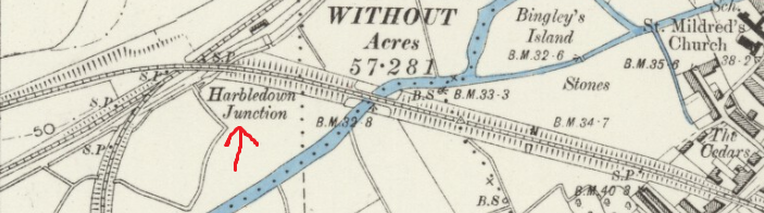
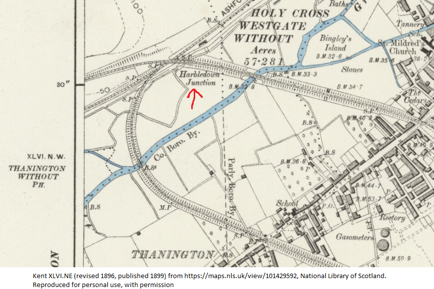
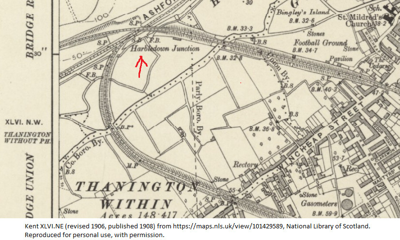
Fast forward a month or two and I recall at work we have access to older maps, so I started speaking to one of my colleagues in the GIS team. They owed me a favour following some Python scripts I wrote for them. Andy helped me locate Harbledown Junction on a map from around 1909 and that's where I got somewhat confused - it never was in Harbledown! Instead the station (still convinced it was a station) was just over half a mile out of the village (as the crow flies). Sadly I can't reproduce that map (copyright reasons) but the National Library of Scotland do offer maps I can reproduce for personal use, so here it is (red arrow annotation added by me):
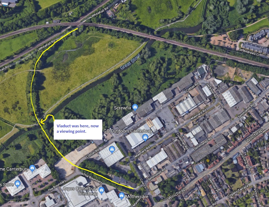
Now I knew where the line went it was easier to locate it on aerial photographs, as seen here provided by Google:
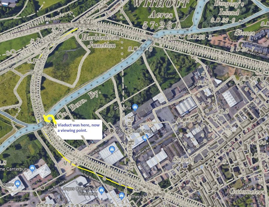
Which if we merge�� the current aerial photo with the historical map shows us:
What's curious is the station doesn't show a building, and isn't annotated with "Sta". Instead there's an "SF" which may relate to Harbledown Junction or possibly another feature as it's written on the trainline itself. If we look at the abbreviations list on the NLS website, SF is just listed as "????" or "side fence", neither of which seem appropriate here. Looking at the other three stations in Canterbury (East, West and South), they each showed quite clear station buildings and were annotated with "Sta". More digging is required.
Looking at the map as published in 1908 (revised in 1906) the true nature of Harbledown Junction is solved, albeit not in the way I wanted it to be:
"SB" is signal box and the "FB" next to it is most likely foot bridge (or filter bed which doesn't mean anything to me). We can also see at the Signalling Record Society that a "type SE box was built here in June 1889". A little research into the Elham Valley railway line (from the same site as linked above) shows the signal box featured in a film called A Canterbury Tale filmed in 1944. The webmaster of the Elham Valley Railway site inform me the still they've used from the movie is out of copyright and have allowed me to reproduce it, so here's the signal box in its glory, around 1944:
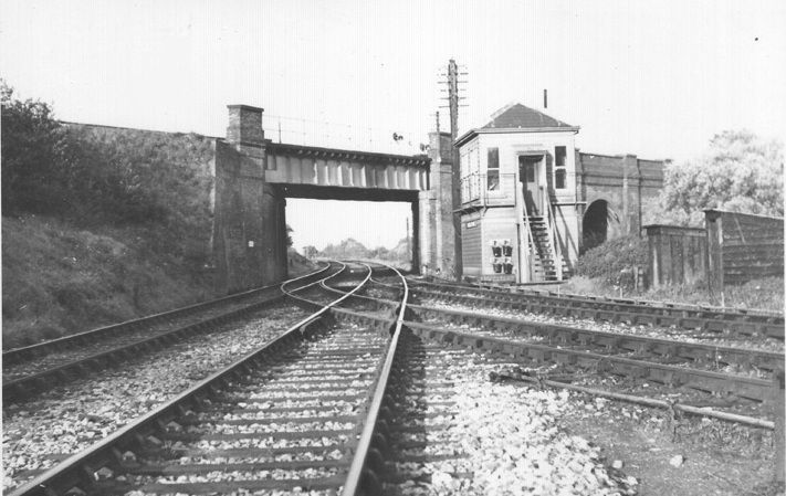
In the background of this photo is Canterbury, with London behind the camera if you were to follow the tracks to the left of the picture (the Canterbury West line). The right hand fork of the track is the Elham Valley line. The bridge across the tracks, and accompanying viaduct come aqueduct, is the Canterbury East line.
Now I know I'm looking for a signal box, not a station, I'm a little disappointed. You might argue that as the later map clearly showed "signal box" that to consider there was still a station was foolhardy - until you consider there's a Sturry station with accompanying Sturry signal box (thus named). I still want to find whatever remains of the signal box and foot bridge (assuming I can legally get there). I know from journeys to London there's no signal box any more, but hopefully there's something left. My brother in law and I quite like going to see random historical things so we set off to find whatever we could. Click for part two!
Banner image from the 1899 map showing Harbledown Junction, as referenced in this post.